Researchers at Colorado State University issued their preliminary Atlantic hurricane season outlook for 2025 on Thursday, and they're predicting it to be more active than normal.
Led by senior researcher, Phil Klotzbach, PhD., the team is forecasting 17 named storms, nine hurricanes and four major hurricanes in the Atlantic basin this season, which runs from June 1 through November 30.
In a typical year, 14 named storms, seven hurricanes and three major hurricanes form. This year’s forecast, then, is only slightly higher than average.

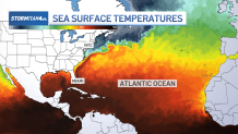
The forecasters think that the main reason for an active season is warm Atlantic water. The Atlantic continues to run warmer than normal, although it is not as warm as it was last year. Warmer water holds more energy to fuel hurricanes, so higher temperatures suggest an active season.

Another indicator of the intensity of a hurricane season is the El Niño Southern Oscillation, or ENSO.
ENSO is the technical term for El Niño and La Niña conditions in the equatorial Pacific Ocean. During an El Niño period, the water temperature here is warmer than normal, which tends to inhibit hurricane formation in the Atlantic basin by creating hostile wind patterns (wind shear) over the Atlantic Ocean that hurricanes don’t flourish in. Conversely, during La Niña periods, the Pacific temperatures run cooler than normal, which leads to wind patterns that are calmer over the Atlantic and more conducive to hurricane development.


This year, a “neutral” pattern is predicted, meaning that temperatures in the Equatorial Pacific are expected to be near normal. This suggests that ENSO may not influence hurricane activity one way or another.
The Colorado State team will update their forecast as the hurricane season progresses and global weather patterns change. But this forecast is a great reminder that hurricane season is right around the corner, and we should have a plan in place in case this year the tri-state area is impacted by a land-falling storm.


