
Spring is officially here and so are spring showers. A soggy Thursday evening will be followed by a dip in temperatures as we settle into the new season.
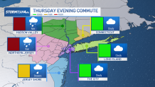
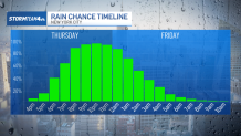
After a cloudy, drizzly, damp day, Thursday evening promises our wettest weather. Rain pushes in early in the evening. The good news: Early evening commuters will avoid the rain altogether, since it does not reach the New York City Metro Area area until 7 p.m. or so. And even when it does arrive, it’s primarily those in the Hudson Valley and North Jersey who should prepare for the wet roads and pockets of heavy rain.
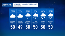
For those in NYC and further east, the rain does not arrive until after dinnertime. As long as your commute gets you home before 8pm, you should avoid most of the rain. But after 8pm you should expect a much soggier drive.
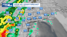
The bulk of the rain will fall between the late evening and early overnight hours. By tomorrow morning, skies will be dry with even some peeks of sunshine starting to break through.
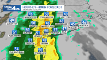
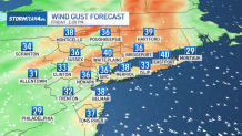
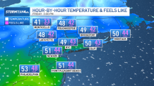
Northwest winds pick up on the heels of this front, keeping us cool and blustery on Friday, as highs stay in the low 50s. While these temperatures are right around average for this time of year, the blustery winds will keep us feeling much cooler. Winds all day will be gusting in the 30 to 40 mph range. This will lead to morning feels like temperatures in the 20s and 30s; chilly enough to make you want to bust out the winter coat again.
Even through the day, as we gain more sunshine, feels like temperatures will staunchly remain in the 30s and 40s all day; a far cry from the mid to upper 60s we were feeling earlier in the week.
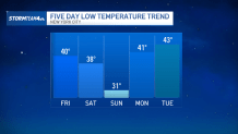
We’ll see temperatures briefly moderate into the weekend, as highs climb back up near 60 on Saturday. But a front comes along Saturday evening, relatively devoid of moisture but strong enough to knock our temperatures down as we head into Sunday; expect freezing morning temperatures and afternoon highs struggling to get into the 50s.
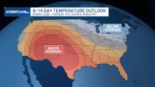
And we’ll stick with theses cooler temperatures for most of the start of spring. We are looking ahead to multiple days with highs only in the 40s next week, along with some rain chances. Forecast models even suggest that these cooler temps will carry through into the start of next month – a humbling reminder that “spring” does not always mean “warm”.


