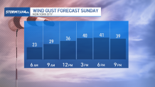
A powerful spring storm is expected to charge into the tri-state area later Sunday afternoon and into the evening, pelting the region with wind gusts up to 40 mph and rainfall rates near an inch an hour at times.
Expect it to be mostly dry during the daylight hours Sunday, with some in the area seeing drizzle and a more moderate rain reaching far northwest New Jersey around sunset. This is the same system bringing deadly storms to the Midwest on Friday and the Southeast on Saturday. Those regions got hammered by strong tornadoes, destructive wind gusts and baseball-sized hail. But the system is not expected to be severe by the time it reaches our area with the strongest weather staying to the south.
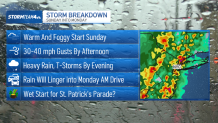
Then it pushes into New York City before midnight. Rain could potentially linger into Monday's morning commute and the start of the St. Patrick's Day Parade on Fifth Avenue, but it is expected to largely move out before the parade start at 11 a.m.
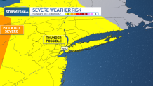
By the time this system makes its way to the tri-state, the greatest severe threat will have passed, but we will still face the chance for isolated severe weather, with the greatest concern being the destructive winds.
Gusts could top 50 mph, which is strong enough to knock branches off trees and even tumble power lines.
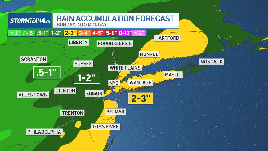
A quick but heavy rainfall could drop up to three inches of rain in parts of the tri-state, including in Connecticut, Long Island, the Jersey Shore and parts of New York City.
Spotty showers start to show up around dinner time, but the real intense rain and storm action moves in between 9 p.m. and midnight.
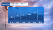
Wind is the biggest concern with the storm, though the gusts are not expected to be as powerful as what we faced last week.

By the morning commute on Monday, showers may still be around, but the greatest storm threat will be over. You should still anticipate some isolated pockets of heavy rain, which will make for reduced visibility at times.
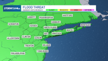
This storm doesn't look to bring any massive flood threat but there is a risk for some minor flooding on low-lying roads and other flood-prone areas. If your commute involves a road with a propensity to flood, give yourself a little extra time for the morning drive and have an alternate route planned as a back-up.
Overall, this system will deliver a decent amount of rain across the region. Most of the area will see at least an inch of rain.


