Nearly three dozen school districts, mainly across New Jersey, announced delayed openings Tuesday after several inches of snow fell overnight. It was one of a series of storms slated to hit the tri-state over the next week.
See the full list of school closures and delays here.
This latest storm brought less accumulation than over the weekend. Snow didn't develop until after the evening commute for most of the New York City metro area, though started in the late afternoon for points south and west of the city, including Philadelphia and Toms River.

The storm tracked well south of the tri-state area and, consequentially, that is where the heaviest snow totals fell.
More wintry weather on the way for New York
By Wednesday morning’s commute, road conditions should be greatly improved, thanks to plows and salt. Regardless, stay vigilant on the roads, because patchy slick spots will be common, especially if you’re an early commuter.
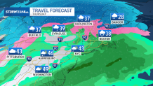
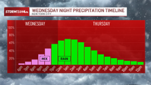
Quick on the heels of the evening/overnight snow, another low ramps up Wednesday night into Thursday. Winter weather advisories are already in place for New York's Sullivan and Ulster counties in anticipation of light snow and ice Wednesday night.
The second system headed to the tri-state this week will not be as forgiving in terms of timing and precipitation type. The timing on this one will involve the Wednesday evening commute and the morning commute Thursday, which may become a soggy mess.
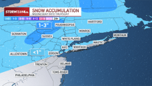
The Catskills and Poconos will see mainly snow and ice. For lower elevations and coastal areas, including the New York City area, it will be a mix of snow and ice that turns over to mainly rain.
Snow accumulations in the mountains will amount to 1-3 inches, while most other areas will pick up less than an inch. And even then, those meager amounts will melt in the rain that follows the snow.
Regardless of precipitation type, this is another system that will have largely moved on prior to the start of the morning commute. Most of us can look forward to nothing more than damp roads, though some light slush or an icy glaze is possible further north in the Hudson Valley.
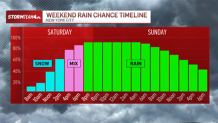
The third system to move through the tri-state area will impact the weekend, ramping up Saturday and continuing through the day on Sunday.
Temperatures this weekend will start below freezing in the city, but will quickly warm to above freezing. That will change the wintry precipitation to all rain. That means less treacherous driving conditions, but your weekend plans might be impacted by the less-than-great weather.
The duration and rainfall rates of this system will make for a decent soaking. And it’s something we’ll watch for potential flood concerns in the coming days.


