
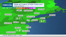
A potent storm system is expected to track through a swath of the eastern and southern United States Monday ahead of a cold front, threatening to bring damaging wind gusts, hail and torrential rain in spots, potentially during the peak evening commute.
The main concern with this system is the intense winds and quick, heavy rainfall -- in addition to the timing.
The storm is expected to impact the New York metro area from about 5 p.m. to 10 p.m. Monday, with rain then moving east of the city after 10 p.m. The greater severe weather threat is south of our area, though the track of the storm could shift. Check the latest severe weather alerts for your neighborhood here.

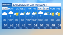
Once the system passes, temperatures drop again.
We have a few more temperature swings to go -- expect a seesaw from around 70 on Monday to the 50s, then lower and back up on Thursday -- and more showers possible by the end of the week.

The early look for next weekend is rain, but that forecast has plenty of time to change.


